File:Ice-floe params hg.png

Size of this preview: 800 × 392 pixels. Other resolutions: 320 × 157 pixels | 640 × 314 pixels | 1,024 × 502 pixels | 1,280 × 628 pixels | 2,800 × 1,373 pixels.
Original file (2,800 × 1,373 pixels, file size: 115 KB, MIME type: image/png)
| ᏄᏍᏛ ᏗᎧᏃᏗ |
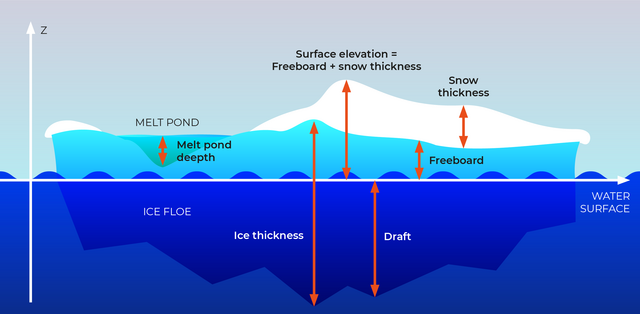
English: Section through an ice floe with parameters used in glaciological research to quantify and describe the coverage of sea ice
Русский: Сечение льдины и её параетры, используемые в гляциологии для описания и количественных оценок покрытия морей льдом.
|
| ᎢᎦ | |
| ᏅᏓᏳᏓᎴᏅᎯ | own work, redrawn from a draft by Valerij Cysko under the supervision of Dr. Christian Haas, geophysicist at Alfred Wegener Institute for Polar and Marine Research, Bremerhaven |
| ᏧᏬᏪᎳᏅᎯ | Amanda Grobe & Hannes Grobe 21:53, 12 August 2006 (UTC), Alfred Wegener Institute for Polar and Marine Research, Bremerhaven, Germany |
| ᏗᏓᎵᏍᎪᎸᏓᏁᎯ (Reusing this file) |
own work, share alike, attribution required (Creative Commons CC-BY-SA-2.5) |
| Other versions | original grafic in Intaglio format available from the author |
I, the copyright holder of this work, hereby publish it under the following license:
This file is licensed under the Creative Commons Attribution-Share Alike 2.5 Generic license.
- You are free:
- to share – to copy, distribute and transmit the work
- to remix – to adapt the work
- Under the following conditions:
- attribution – You must give appropriate credit, provide a link to the license, and indicate if changes were made. You may do so in any reasonable manner, but not in any way that suggests the licensor endorses you or your use.
- share alike – If you remix, transform, or build upon the material, you must distribute your contributions under the same or compatible license as the original.

|
This geology image could be re-created using vector graphics as an SVG file. This has several advantages; see Commons:Media for cleanup for more information. If an SVG form of this image is available, please upload it and afterwards replace this template with
{{vector version available|new image name}}.
It is recommended to name the SVG file “Ice-floe params hg.svg”—then the template Vector version available (or Vva) does not need the new image name parameter. |
File history
Click on a date/time to view the file as it appeared at that time.
| ᎢᎦ/ᎠᏟᎢᎵᏒ | ᎤᏍᏗ ᏓᏟᎶᏍᏛᎢ | Dimensions | ᎬᏗᏍᎩ | ᏍᏆᎳ ᎪᏪᎵ | |
|---|---|---|---|---|---|
| current | 21:29, 24 ᏚᎵᎢᏍᏗ 2023 | | 2,800 × 1,373 (115 KB) | Beao | Cropped 13 % vertically using CropTool with lossless mode. Removed watermark. |
| 23:10, 20 ᎧᏩᏂ 2022 |  | 2,800 × 1,576 (130 KB) | RASPBERRY VIBE | Image resolution increase, data structuring. | |
| 04:42, 21 ᎦᎶᏂᎢ 2006 |  | 675 × 376 (157 KB) | Hgrobe | {{Information| |Description=Section through an ice floe with parameters used in glaciological research to quantify and describe the coverage of sea ice * '''Ice thickness''': total thickness of the ice floe (draft + freeboard) * '''Freeboard''': part of t | |
| 04:34, 21 ᎦᎶᏂᎢ 2006 |  | 783 × 559 (163 KB) | Hgrobe | {{Information| |Description=Section through an ice floe with parameters used in glaciological research to quantify and describe the coverage of sea ice * '''Ice thickness''': total thickness of the ice floe (draft + freeboard) * '''Freeboard''': part of t | |
| 21:53, 12 ᎦᎶᏂᎢ 2006 |  | 1,006 × 557 (261 KB) | Hgrobe | {{Information| |Description=Section through an ice floe with parameters used in glaciological research to quantify and describe the coverage of sea ice |Source=own work |Date=2006-08-08 |Author=~~~~ |Permission=Own work, share alike, attribution required |
File usage
There are no pages that use this file.
Global file usage
The following other wikis use this file:
- Usage on be.wikipedia.org
- Usage on bn.wikipedia.org
- Usage on ca.wikipedia.org
- Usage on cv.wikipedia.org
- Usage on de.wikipedia.org
- Usage on el.wikipedia.org
- Usage on en.wikipedia.org
- Usage on en.wiktionary.org
- Usage on es.wikipedia.org
- Usage on it.wikipedia.org
- Usage on ja.wikipedia.org
- Usage on ko.wikipedia.org
- Usage on mnw.wiktionary.org
- Usage on nl.wikipedia.org
- Usage on nn.wikipedia.org
- Usage on no.wikipedia.org
- Usage on simple.wikipedia.org
- Usage on uk.wikipedia.org
- Usage on zh.wikipedia.org
- Usage on zh.wiktionary.org